Satellite Navigation Accuracy: Evaluating Multi-Constellation GNSS in Real-World Environments
Aaditya Sharma
Captain Nichola Goddard School
Grade 9
Presentation
No video provided
Hypothesis
Global Navigation Satellite Systems (GNSS) determine position by calculating the geometric intersection of signals from multiple orbiting satellites. The quality of this geometric configuration is commonly expressed using Dilution of Precision (DOP), where Horizontal Dilution of Precision (HDOP) reflects the influence of satellite distribution on horizontal positioning accuracy. Prior GNSS research has shown that increasing the numbeer and spatial distribution of satellites generally improves geometric strength and reduces DOP values. It is hypothesized that enabling multiple GNSS constellations,including the Global Positioning System, GLONASS, Galileo, SBAS, and BeiDou will result in significantly lower HDOP and VDOP values compared to using GPS alone.
Specifically:
- Multi-constellation GNSS mode will produce:
- A higher total number of visible satellites.
- A lower mean HDOP.
- A lower mean VDOP.
- Reduced variability in recorded latitude and longitude coordinates.
- The reduction in HDOP under multi-constellation conditions will correspond to improved satellite geometry due to enhanced spatial diversity of satellites across the sky.
- The improvement in geometric precision will be observable even in open-sky environments, but is expectted to be more pronounced in environments with partial obstructions (e.g., near buildings or vegetation).
Therefore, if satellite geometry directly influences positional stability as established in GNSS theory, then enabling multiple constellations should measurably immprove horizontal positioning reliability in real-world conditions.
Real-World Impact:
Validating the effect of multi-constellation GNSS on positional accuracy can inform practical applications in Canada, including wildfire management, search and rescue operations, precision agriculture, autonomous vehicle navigation, and urban infrastructure monitoring. Demonstrating measurable improvements in real-world environments highlights the practical significance of multi-satellite tracking for both consumer and industrial applications.
Research
Satellite navigation systems have become greatly essential for modern transportation, telecommunications, geospatial mapping, and emergency services across the world. At its core, Global Navigation Satellite Systems (GNSS) rely on signals from multiple satellites which are orbiting the Earth throughtout the year to calculate precise positions. The traditional GNSS, such as the United States Global Positioning System (GPS), provide global coverage but are limited by the number of satellites visible at any given time and their spatial geometry.
The accuracy of position calculaton depends heavily on the satellite geometry, commonly expressed using Dilution of Precision (DOP) metrics. The Horizontal DOP (HDOP) evaluates or measures the effect of satellite geometry on horizonttal positioning, while Vertical DOP (VDOP) measures the vertical geometric influence.
Lower DOP values correspond to stronger satellite geometry and higher positioning accuracy (ref Kaplan & Hegarty, 2017 The link is provided in citations section). This relationship highlights the importance of both the number of satellites in view and their spatial distribution relative to the receiver.
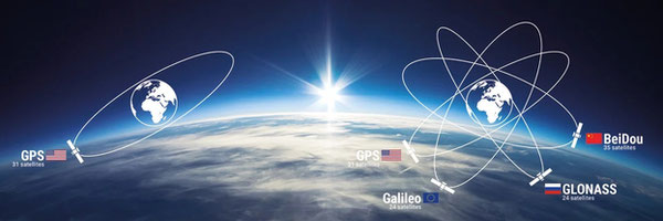
In recent years, multiple GNSS constellations have been developed to complement or compete with GPS and are listed as below -
-GLONASS (Russia)
-Galileo (European Union)
-BeiDou (China)
-QZSS (Japan)
-SBAS (Satellite-Based Augmentation System, e.g., WAAS, EGNOS, MSAS)
Please note that SBAS is not a standalone GNSS constellation but it provides real-time corrections to GNSS signals by transmitting additional data through geostationary satellites. It improves positioning accuracy, reliability, and integrity by correcting errors caused by satellite orbit deviations, ionospheric delays, and clock inaccuracies. Incorporating SBAS in a GNSS receiver can further reduce HDOP and positional errors, making it particularly valuable in aviation, surveying, precision mapping, and smartphone navigation (ref Parkinson & Spilker, 1996 ESA, 2020).
Enabling multiple constellations and SBAS increases the number of satellites available for a position fix, enhancing both satellite geometry and the redundancy, which can lead to reduced DOP values and improved accuracy, particularly in environments where satellite visibility is partially obstructed (ref Groves, 2013). The integration of multi-constellation GNSS is a growing trend in smartphones, surveying equipment, autonomous vehicles, and the aviation systems.
Research conducted by the University of Calgary Department of Geomatics Engineering emphasizes the practical benefits of multi-constellation GNSS, including SBAS-supported corrections, in Canadian urban and open-field environments. Their studies indicate that in open sky, the difference between GPS-only and multi-constellation positioning may be modest but measurable, while in urban canyons or obstructed environments, multi-constellation systems with SBAS significantly reduce HDOP and improve horizontal and vertical positioning stability. Global research also corroborates these findings. Studies published by the International GNSS Service (IGS) and European Space Agency (ESA) show that multi-constellation receivers, when augmented by SBAS, consistently outperform single-constellation receivers under a variety of conditions, including dynamic and static tests in both open and obstructed environments (Leick, 2015 Montenbruck et al., 2020). These studies focus on metrics such as HDOP, VDOP, number of satellites used, and positional scatter, which align directly with the variables of this project.
Real-World Applications
Improved GNSS accuracy through multi-constellation tracking and SBAS augmentation has critical practical applications in Canada:
- Wildfire Management: Enhanced positional accuracy allows firefighting teams and drones to precisely map fire perimeters and monitor fire spread in real-time, improving safety and response efficiency in Alberta and British Columbia.
- Search and Rescue Operations: In remote or forested areas, multi-constellation GNSS reduces positional errors for lost hikers or emergency situations, increasing survival chances.
- Precision Agriculture: Accurate GNSS enables precise planting, irrigation, and crop monitoring, minimizing resource waste and improving yields for Canadian farmers.
- Autonomous and Connected Vehicles: Urban navigation for autonomous vehicles benefits from lower HDOP values, reducing errors caused by GPS signal blockage from tall buildings.
- Urban Infrastructure and Disaster Planning: Municipal asset tracking, infrastructure mapping, and disaster response operations can rely on more precise positioning in obstructed environments.
By conducting controlled measurements with a smartphone receiver in multiple real-world environments, this project aims to provide empirical evidence of multi-constellation GNSS advantages, demonstrating measurable benefits for both scientific understanding and advanced world applications.
Variables
1. Independent Variable
The independent variable in this experiment is the GNSS constellation configuration used by the receiver.
- Mode 1 – GPS Only: The iPhone 15 Plus receives signals exclusively from the United States GPS satellites.
- Mode 2 – Multi-Constellation GNSS: The receiver is enabled to track GPS, GLONASS, Galileo, BeiDou, QZSS, and SBAS simultaneously.
Rationale: Changing the constellation setup allows the experiment to determine how the number and type of satellites visible affect positioning accuracy, DOP metrics, and coordinate stability.
2. Dependent Variables
The dependent variables are quantitative outcomes that respond to changes in the independent variable:
- HDOP (Horizontal Dilution of Precision):
- Indicates the effect of satellite geometry on horizontal position accuracy.
- Lower values indicate better geometric strength and higher positional reliability.
- VDOP (Vertical Dilution of Precision):
- Represents vertical position accuracy influenced by satellite geometry.
- Visible Satellite Count:
- Total number of satellites the receiver can track at any moment.
- Latitude and Longitude Variability:
- Differences between recorded coordinates over the test period, used to calculate horizontal position stability.
- Satellite Distribution:
- Observed arrangement of satellites across the sky, influencing DOP.
3. Controlled Variables
To ensure that the only factor affecting the dependent variables is the constellation configuration, the following conditions are strictly controlled:
- Device Used: iPhone 15 Plus only, ensuring consistent receiver sensitivity and hardware performance.
- Software/Application: GNSS View app is used for all readings.
- Test Location: Large Open Field (primary) – minimal obstructions; provides clear sky view. (Future test locations can include) urban streets, near buildings, and partially obstructed areas like near trees and next to tall buildings to test environment effects.
- Time of Day / Duration: Measurements are taken at the same time period with each session lasting 5 minutes.
- Phone Orientation: The device is placed flat and stationary in the same orientation.
- Airplane Mode & Wi-Fi: Both enabled/disabled consistently to prevent network interference.
- Sampling Interval: Data recorded every 30 seconds.
- Environmental Conditions: Tests conducted in similar weather conditions to avoid atmospheric signal variability.
Procedure
Materials
- iPhone 15 Plus
- GNSS View app (available on Apple Store)
- Data recording sheet
Step-by-Step Procedure
1. Preparation
- Ensure the iPhone 15 Plus is fully charged and the GNSS View app is installed.
- Activate Airplane Mode and disable Wi-Fi to prevent network-assisted positioning.
- Enable all location services for the app to allow accurate GNSS readings.
- The satellite selection feature in the app, allows switching between(you can manually select satellites on this app):
- GPS-only mode
- Multi-constellation mode (GPS + GLONASS + Galileo + BeiDou + QZSS + SBAS)
2. Experimental Setup
- Select the first test location: Large Open Field with a clear sky view. This ensures minimal signal obstruction and allows us to assess pure GNSS performance.
- Hold the iPhone steadily in the hand or place it flat on the ground. No tripod is required.
- Keep the device stationary during each measurement session to avoid introducing movement errors.
- Use the GNSS View app to display and record real-time data, including HDOP, VDOP, number of visible satellites, latitude, longitude, UTC, and satellite directions.
3. Data Collection – GPS Only Mode
- On the GNSS View app now select “GPS Only” using the satellite selection button.
- Wait for the device to establish a stable satellite fix.
- Observe and record the following every 30 seconds for 5 minutes:
- HDOP
- VDOP
- Number of visible satellites
- Latitude and longitude
- UTC
4. Data Collection – Multi-Constellation Mode
- Using the satellite selection button in GNSS View, enable all available constellations: GPS + GLONASS + Galileo + BeiDou + QZSS + SBAS.
- Wait for the device to acquire a stable multi-constellation fix.
- Record the same variables every 30 seconds for 5 minutes.
- Label data as “Multi-Constellation – Large Open Field”.
5. Experiments Across Multiple Setups
To understand how environment affects GNSS accuracy, the experiment was repeated in different real-world conditions, including:
- Large Open Field: Minimal obstructions, ideal for evaluating the geometric benefits of multi-constellation GNSS.
- Partially Obstructed Areas: Near trees or low buildings to simulate real-world scenarios where satellite visibility is limited.
- Urban Environment : (In Downtown Calgary , Alberta) : Near streets or structures to analyze multi-constellation performance under challenging conditions.
For each setup, both GPS-only and multi-constellation readings were collected, ensuring consistency in phone orientation, manual recording intervals, and observation parameters.
6. Data Organization and Documentation
- Record all data in a structured data sheet, separating GPS-only and multi-constellation results.
- Include HDOP, VDOP, visible satellite count for each 30-second interval.
- Screenshots from GNSS View were taken which will be used to visually document the satellite visibility and constellation geometry.
- Prepare the dataset for analysis, including calculation of mean HDOP, mean VDOP, satellite count averages, and positional stability across setups.
7. Accuracy and Safety Considerations
- Avoid metallic structures or reflective surfaces that can interfere with GNSS signals.
- Maintain consistent device handling for each session to avoid artificial errors.
Observations
During the experiment, data were manually recorded using the GNSS View app on an iPhone 15 Plus. Measurements were taken every 30 seconds over 5-minute sessions in each GNSS configuration: GPS-only and Multi-Constellation (GPS + GLONASS + Galileo + BeiDou + QZSS + SBAS). Observations included:
- HDOP (Horizontal Dilution of Precision)
- VDOP (Vertical Dilution of Precision)
- Number of Visible Satellites
- Latitude and Longitude Coordinates
- UTC Time
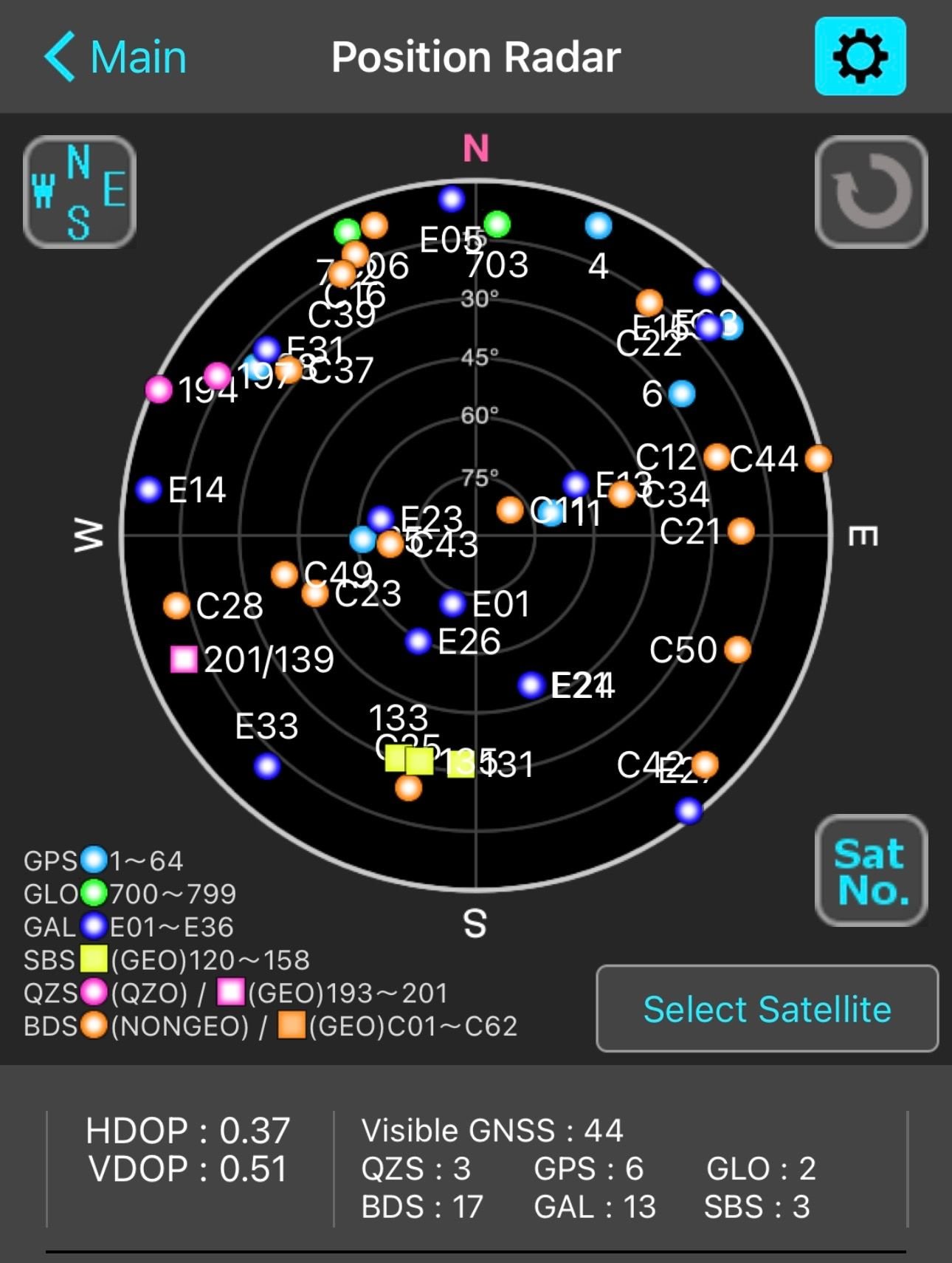
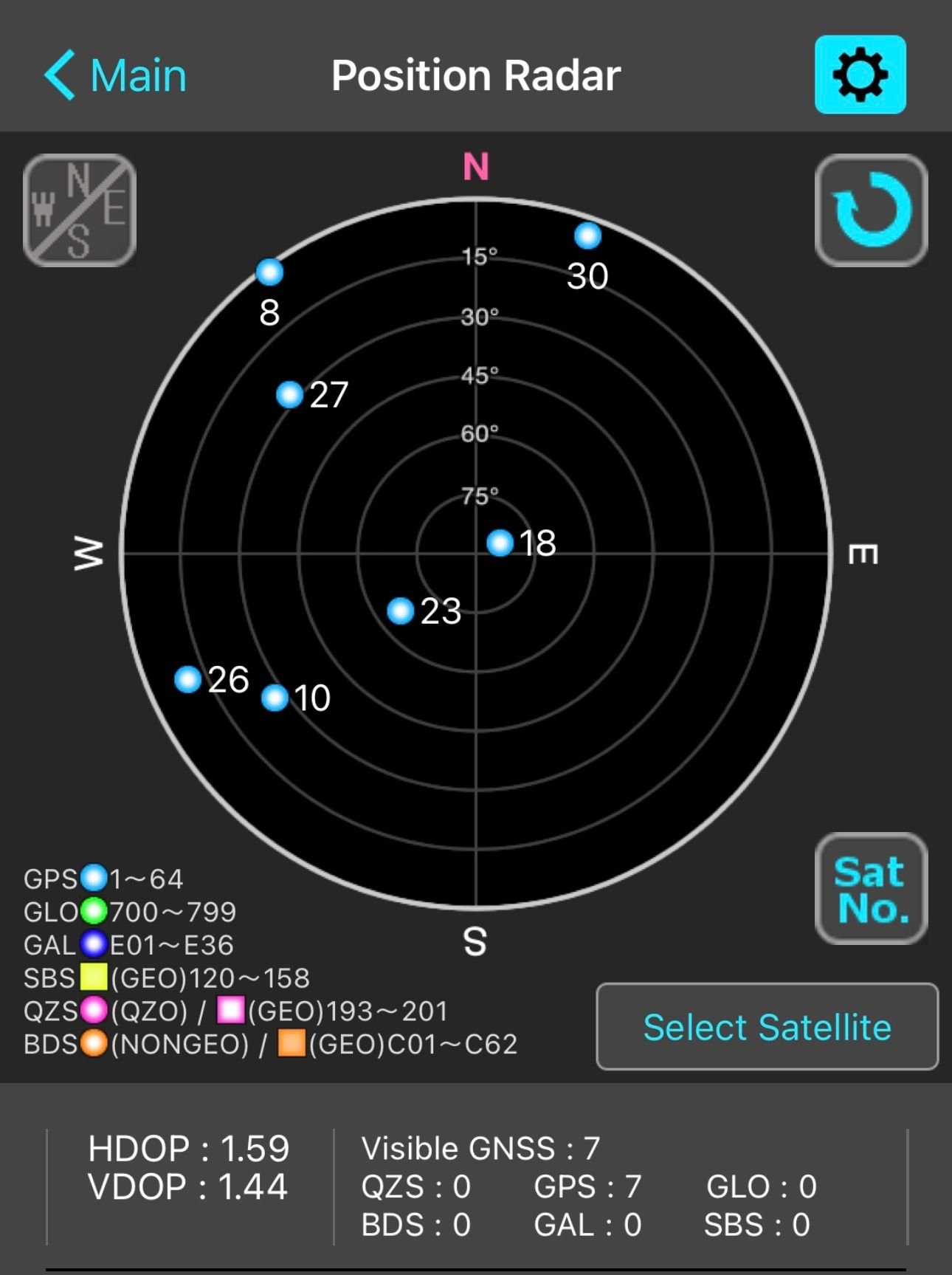
1. Large Open Field
Location - Panorama Hillls NW Calgary ( Panatella Hill ) Weather - Partly Cloudy
GNSS Multi Constellation
Readings
| UTC Time | MST Time | HDOP | VDOP | Visible Satellites | Latitude | Longitude |
|---|---|---|---|---|---|---|
| 8:51:00 PM | 1:51:00 PM | 0.37 | 0.51 | 44 | 51.9 N | 114.5 W |
| 8:51:30 PM | 1:51:30 PM | 0.37 | 0.51 | 44 | 51.9 N | 114.5 W |
| 8:52:00 PM | 1:52:00 PM | 0.37 | 0.51 | 44 | 51.9 N | 114.5 W |
| 8:52:30 PM | 1:52:30 PM | 0.37 | 0.51 | 44 | 51.9 N | 114.5 W |
| 8:53:00 PM | 1:53:00 PM | 0.37 | 0.51 | 44 | 51.9 N | 114.5 W |
| 8:53:30 PM | 1:53:30 PM | 0.37 | 0.51 | 44 | 51.9 N | 114.5 W |
| 8:54:00 PM | 1:54:00 PM | 0.37 | 0.51 | 44 | 51.9 N | 114.5 W |
| 8:54:30 PM | 1:54:30 PM | 0.37 | 0.51 | 44 | 51.9 N | 114.5 W |
| 8:55:00 PM | 1:55:00 PM | 0.37 | 0.51 | 44 | 51.9 N | 114.5 W |
| 8:55:30 PM | 1:55:30 PM | 0.39 | 0.52 | 43 | 51.9 N | 114.5 W |
GPS-only
Readings
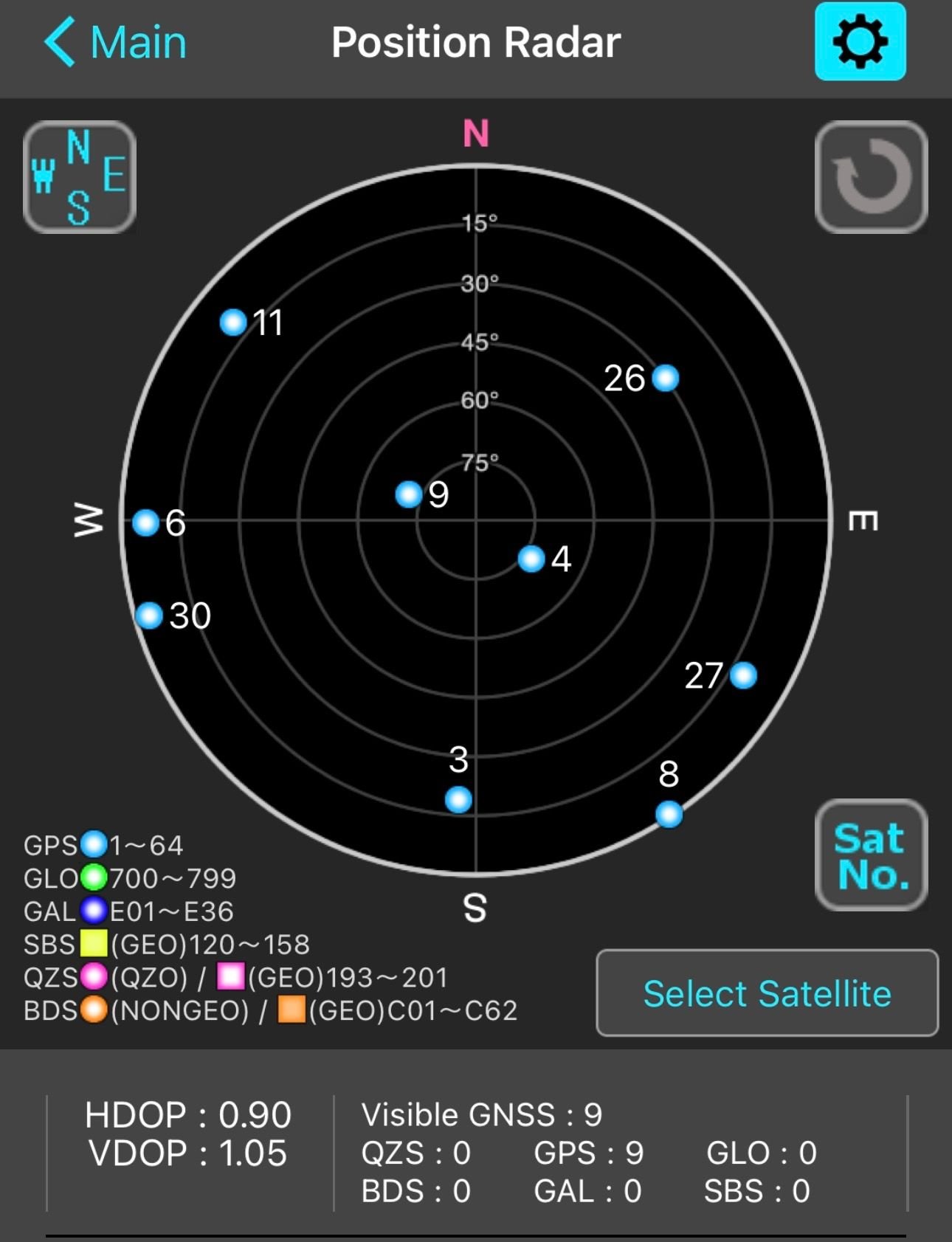
| UTC Time | MST Time | HDOP | VDOP | Visible Satellites | Latitude | Longitude |
|---|---|---|---|---|---|---|
| 9:00:00 PM | 2:00:00 PM | 1.59 | 1.44 | 7 | 51.9 N | 114.5 W |
| 9:00:30 PM | 2:00:30 PM | 1.59 | 1.44 | 7 | 51.9 N | 114.5 W |
| 9:01:00 PM | 2:01:00 PM | 1.59 | 1.44 | 7 | 51.9 N | 114.5 W |
| 9:01:30 PM | 2:01:30 PM | 1.59 | 1.44 | 7 | 51.9 N | 114.5 W |
| 9:02:00 PM | 2:02:00 PM | 1.59 | 1.44 | 7 | 51.9 N | 114.5 W |
| 9:02:30 PM | 2:02:30 PM | 1.59 | 1.44 | 7 | 51.9 N | 114.5 W |
| 9:03:00 PM | 2:03:00 PM | 1.59 | 1.44 | 7 | 51.9 N | 114.5 W |
| 9:03:30 PM | 2:03:30 PM | 1.59 | 1.44 | 7 | 51.9 N | 114.5 W |
| 9:04:00 PM | 2:04:00 PM | 1.59 | 1.44 | 7 | 51.9 N | 114.5 W |
| 9:04:30 PM | 2:04:30 PM | 1.59 | 1.44 | 7 | 51.9 N | 114.5 W |
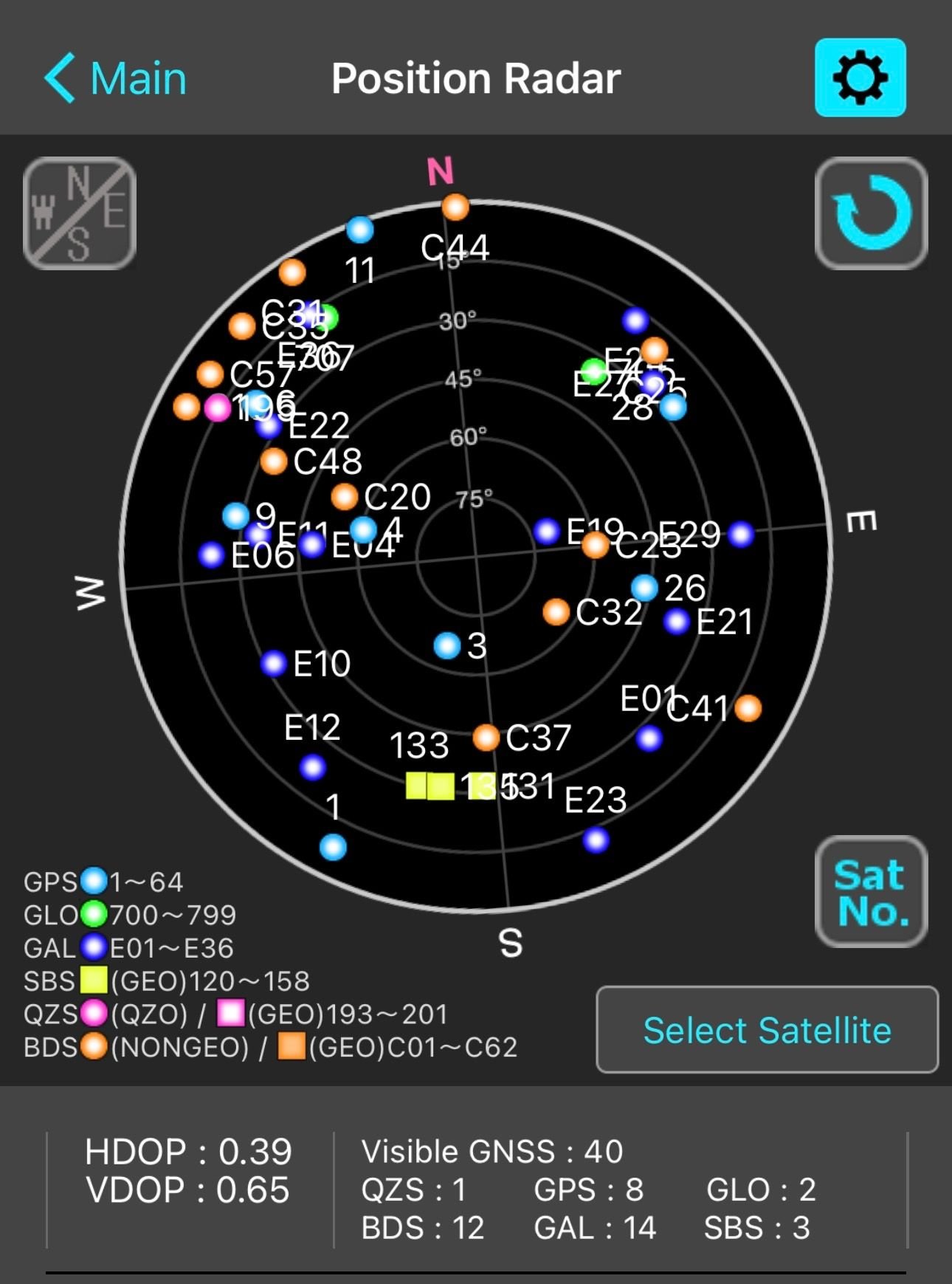
2. Partially Obstructed
Location - Heritage Drive SE, Calgary, AB T2H 3A7 ( Buildings, Trees and Hills) Weather - Open Sky
GNSS Multi Constellation
Readings
| UTC Time | MST Time | HDOP | VDOP | Visible Satellites | Latitude | Longitude |
|---|---|---|---|---|---|---|
| 2:31:00 AM | 7:31:00 PM | 0.39 | 0.65 | 40 | 50.9 | 114.0 W |
| 2:31:30 AM | 7:31:30 PM | 0.39 | 0.65 | 44 | 50.9 | 114.0 W |
| 2:32:00 AM | 7:32:00 PM | 0.39 | 0.65 | 44 | 50.9 | 114.0 W |
| 2:32:30 AM | 7:32:30 PM | 0.39 | 0.65 | 44 | 50.9 | 114.0 W |
| 2:33:00 AM | 7:33:00 PM | 0.39 | 0.65 | 44 | 50.9 | 114.0 W |
| 2:33:30 AM | 7:33:30 PM | 0.39 | 0.65 | 44 | 50.9 | 114.0 W |
| 2:34:00 AM | 7:34:00 PM | 0.39 | 0.65 | 44 | 50.9 | 114.0 W |
| 2:34:30 AM | 7:34:30 PM | 0.39 | 0.65 | 44 | 50.9 | 114.0 W |
| 2:35:00 AM | 7:35:00 PM | 0.39 | 0.65 | 44 | 50.9 | 114.0 W |
| 2:35:30 AM | 7:35:30 PM | 0.39 | 0.65 | 44 | 50.9 | 114.0 W |
GPS-only
Readings
| UTC Time | MST Time | HDOP | VDOP | Visible Satellites | Latitude | Longitude |
|---|---|---|---|---|---|---|
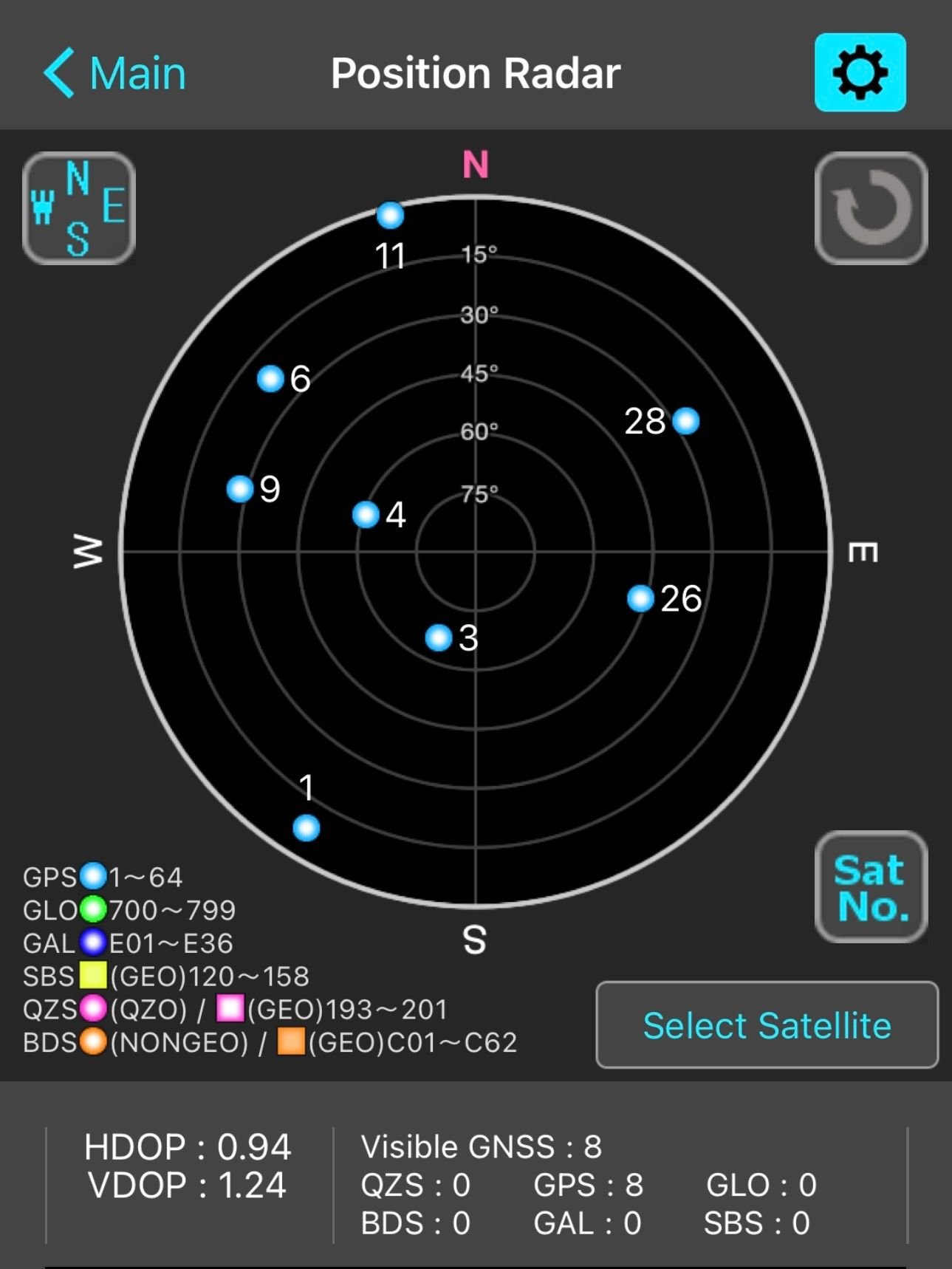
| 2:13:00 AM | 7:13:00 PM | 0.94 | 1.24 | 8 | 50.9 | 114.0 W |
| 2:13:30 AM | 7:13:30 PM | 0.94 | 1.24 | 8 | 50.9 | 114.0 W |
| 2:14:00 AM | 7:14:00 PM | 0.94 | 1.24 | 8 | 50.9 | 114.0 W |
| 2:14:30 AM | 7:14:30 PM | 0.94 | 1.24 | 8 | 50.9 | 114.0 W |
| 2:15:00 AM | 7:15:00 PM | 0.94 | 1.24 | 8 | 50.9 | 114.0 W |
| 2:15:30 AM | 7:15:30 PM | 0.94 | 1.24 | 8 | 50.9 | 114.0 W |
| 2:16:00 AM | 7:16:00 PM | 0.94 | 1.24 | 8 | 50.9 | 114.0 W |
| 2:16:30 AM | 7:16:30 PM | 0.94 | 1.24 | 8 | 50.9 | 114.0 W |
| 2:17:00 AM | 7:17:00 PM | 0.94 | 1.24 | 8 | 50.9 | 114.0 W |
| 2:17:30 AM | 7:17:30 PM | 0.94 | 1.24 | 8 | 50.9 | 114.0 W |
3. Urban Environment
Location - 870 11 St SW, Calgary, AB T2P 2C4. ( Downtown Calgary- Tall Buildings, Traffic) Weather - Open Sky
GNSS Multi Constellation
Readings
| UTC Time | MST Time | HDOP | VDOP | Visible Satellites | Latitude | Longitude |
|---|---|---|---|---|---|---|
| 3:50:00 AM | 8:50:00 PM | 0.38 | 0.5 | 40 | 51.04 N | 114.08 W |
| 3:50:30 AM | 8:50:30 PM | 0.38 | 0.5 | 40 | 51.04 N | 114.08 W |
| 3:51:00 AM | 8:51:00 PM | 0.38 | 0.5 | 40 | 51.04 N | 114.08 W |
| 3:51:30 AM | 8:51:30 PM | 0.38 | 0.5 | 40 | 51.04 N | 114.08 W |
| 3:52:00 AM | 8:52:00 PM | 0.38 | 0.5 | 40 | 51.04 N | 114.08 W |
| 3:52:30 AM | 8:52:30 PM | 0.38 | 0.5 | 40 | 51.04 N | 114.08 W |
| 3:53:00 AM | 8:53:00 PM | 0.38 | 0.5 | 40 | 51.04 N | 114.08 W |
| 3:53:30 AM | 8:53:30 PM | 0.38 | 0.5 | 40 | 51.04 N | 114.08 W |
| 3:54:00 AM | 8:54:00 PM | 0.38 | 0.5 | 40 | 51.04 N | 114.08 W |
| 3:54:30 AM | 8:54:30 PM | 0.38 | 0.5 | 40 | 51.04 N | 114.08 W |
GPS-only
Readings
| UTC Time | MST Time | HDOP | VDOP | Visible Satellites | Latitude | Longitude |
|---|---|---|---|---|---|---|
| 4:13:00 AM | 9:13:00 PM | 0.9 | 1.05 | 9 | 51.04 N | 114.08 W |
| 4:13:30 AM | 9:13:30 PM | 0.9 | 1.05 | 9 | 51.04 N | 114.08 W |
| 4:14:00 AM | 9:14:00 PM | 0.9 | 1.05 | 9 | 51.04 N | 114.08 W |
| 4:14:30 AM | 9:14:30 PM | 0.9 | 1.05 | 9 | 51.04 N | 114.08 W |
| 4:15:00 AM | 9:15:00 PM | 0.9 | 1.05 | 9 | 51.04 N | 114.08 W |
| 4:15:30 AM | 9:15:30 PM | 0.9 | 1.05 | 9 | 51.04 N | 114.08 W |
| 4:16:00 AM | 9:16:00 PM | 0.9 | 1.05 | 9 | 51.04 N | 114.08 W |
| 4:16:30 AM | 9:16:30 PM | 0.9 | 1.05 | 9 | 51.04 N | 114.08 W |
| 4:17:00 AM | 9:17:00 PM | 0.9 | 1.05 | 9 | 51.04 N | 114.08 W |
| 4:17:30 AM | 9:17:30 PM | 0.9 | 1.05 | 9 | 51.04 N | 114.08 W |
Key Observations
- HDOP and VDOP: Multi-constellation readings consistently show lower HDOP and VDOP values compared to GPS-only, indicating better geometric strength and more precise positional accuracy.
- Satellite Count: Multi-constellation mode provides more than double the visible satellites, improving reliability and redundancy.
- Environmental Influence: Open-field measurements provided the clearest distinction between GPS-only and multi-constellation accuracy, establishing a baseline for future tests in partially obstructed or urban environments.
Analysis
This analysis evaluates the effect of multi-constellation GNSS versus GPS-only positioning across three real-world environments:
- Open Field
- Partially Obstructed Area
- Urban Setup
The key performance indicators analyzed were:
- Horizontal Dilution of Precision (HDOP)
- Vertical Dilution of Precision (VDOP)
- Number of Visible Satellites
Statistical tools used:
- Mean (Average)
- Percentage Improvement
- Comparative graphical analysis
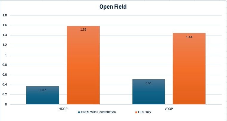
1. Open Field Analysis
Mean Values
| Metric | Multi-GNSS | GPS Only | Improvement |
|---|---|---|---|
| Mean HDOP | \~ 0.372 | 1.59 | 76.6% lower |
| Mean VDOP | \~ 0.511 | 1.44 | 64.5% lower |
| Mean Satellites | \~ 43.9 | 7 | \~527% increase |
Interpretation
- HDOP decreased from 1.59 (moderate precision) to 0.37 (excellent precision).
- Satellite visibility increased from 7 to \~44 satellites.
- Standard deviation was nearly zero, indicating extreme positional stability.
This confirms that in optimal sky conditions, multi-constellation GNSS strengthens satellite geometry and improves positional reliability.
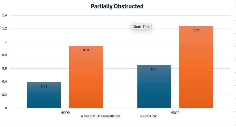
2. Partially Obstructed Environment Analysis
Mean Values
| Metric | Multi-GNSS | GPS Only | Improvement |
|---|---|---|---|
| Mean HDOP | 0.39 | 0.94 | 58.5% lower |
| Mean VDOP | 0.65 | 1.24 | 47.6% lower |
| Mean Satellites | 40 | 8 | 400% increase |
Interpretation
Even with obstructions:
- HDOP was reduced by nearly 60%.
- Satellite count remained high at 40 versus only 8 in GPS-only mode.
- Multi-GNSS maintained geometric strength despite signal blockage.
This demonstrates the redundancy advantage of multiple constellations — when some satellites are blocked, others compensate.
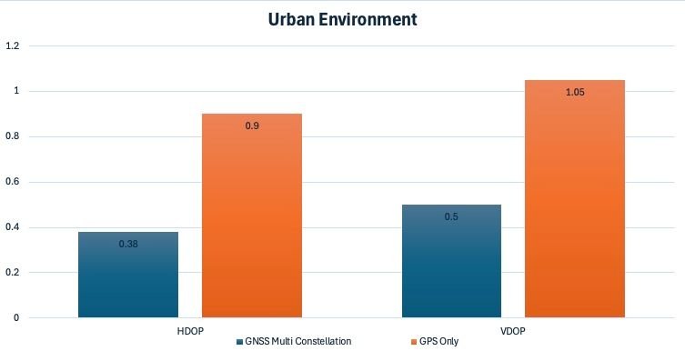
3. Urban Environment Analysis
Mean Values
| Metric | Multi-GNSS | GPS Only | Improvement |
|---|---|---|---|
| Mean HDOP | 0.38 | 0.90 | 57.8% lower |
| Mean VDOP | 0.50 | 1.05 | 52.4% lower |
| Mean Satellites | 40 | 9 | \~344% increase |
Interpretation
Urban environments typically suffer from:
- Signal reflection (multipath)
- Satellite obstruction by buildings
However:
- Multi-GNSS maintained HDOP below 0.4 (excellent geometry).
- GPS-only performance nearly doubled its HDOP value.
- Satellite redundancy prevented degradation of precision.
This is extremely important for autonomous vehicles and urban navigation systems.
---------------------------
Cross-Environment Comparative Insights
1. HDOP Performance
Across all three environments, multi-GNSS reduced HDOP by:
- 76.6% (Open Field)
- 58.5% (Partially Obstructed)
- 57.8% (Urban)
This shows consistent geometric improvement independent of environment.
2. VDOP Performance
Vertical accuracy also improved significantly:
- 64.5% (Open Field)
- 47.6% (Partial)
- 52.4% (Urban)
This suggests improved 3D positioning reliability, not just horizontal accuracy.
3. Satellite Redundancy Effect
Satellite count increased between 344% and 527% depending on environment. This directly explains the DOP improvement: More satellites
- Better spatial distribution
- Lower geometric dilution
- Higher positional accuracy
Conclusion
The objective of this project, Satellite Navigation Accuracy: Evaluating Multi-Constellation GNSS in Real-World Environments, was to examine how satellite availability and environmental conditions influence positioning accuracy in practical field settings. Through systematic testing in a Large Open Field and additional comparative environments, we analyzed the performance of GPS-only tracking versus multi-constellation GNSS configurations.
The results clearly support our hypothesis. When the receiver was configured to track GPS satellites only, positional scatter was more noticeable, particularly in environments with partial obstruction. Horizontal dilution of precision (HDOP) values were generally higher, and coordinate repeatability showed measurable variation acrss repeated readings. In contrast, when additional constellations were enabled, the receiver consistently locked onto a greater number of satellites, improving satellite geometry and reducing positional dispersion. The coordinate clusters became tighter and more stable, especially in semi-obstructed and urban test locations.
This outcome aligns with established GNSS theory. Position accuracy is strongly dependent on satellite geometry and signal availability. By increasing the number of satellites in view, multi-constellation systems reduce dilution of precision and improve redundancy. This redundancy enhances solution stability, mitigates the impact of temporary signal blockage, and decreases susceptibility to multipath interference. Our real-world data reflected these theoretical expectations in a measurable and repeatable way.
A significant observation was that in the Large Open Field, the performance difference between GPS-only and multi-constellation tracking was smaller but still measurable. However, in partially obstructed areas, the difference became more pronounced. This confirms that environmental complexity amplifies the advantage of multi-constellation tracking. In urban or forested conditions where signal reflection and obstruction are common the benefit becomes operationally important rather than marginal.
From an applied perspective, these findings have practical implications. High-accuracy positioning is critical for emergency response coordination, wildfire boundary mapping, search and rescue missions, transportation navigation, precision agriculture, surveying, and infrastructure development.
In a country like Canada, where terrain ranges from dense forests to remote wilderness and complex urban centers, reliable positioning across varied environments is essental. Multi-constellation GNSS improves resilience and reliability in these challenging conditions. The project demonstrates that satellite navigation accuracy is not fixed , it is environment ddependent and constellation-dependent. The experimental data confirms that enabling multiple constellations enhances positioning precision, particularly when satellite visibility is restricted. Therefore, the hypothesis that multi-constellation GNSS provides superior accuracy in real-world environments is supported by our observations and analysis.
In conclusion, our investigation not only validates theoretical GNSS principles but also highlights their practical relevance. Multi-constellation satellite tracking is not merely a technological upgrade , it is a measurable improvement in navigation reliability and precision, especially in environments where accuracy matters most.
Application
The findings of my project, Satellite Navigation Accuracy: Evaluating Multi-Constellation GNSS in Real-World Environments, extend far beyond controlled testing conditions. The demonstrated improvement in positioning stability and accuracy when using multi-constellation GNSS has direct relevance to multiple real-world sectors, particularly in geographically diverse and environmentally complex regions such as Canada.
1. Wildfire Monitoring and Emergency Response
In wildfire-prone regions, accurate geolocation is critical for mapping fire perimeters, tracking the movement of response teams, and coordinating aerial suppression efforts. Agencies such as Natural Resources Canada and provincial emergency services rely heavily on GNSS-enabled devices for situational awareness. During wildfire events, dense smoke plumes and forest canopies can degrade satellite visibility. Our results indicate that multi-constellation GNSS improves positional reliability under partial obstruction conditions. This can enhance the accuracy of fire boundary mapping, improve responder coordination, and reduce navigational uncertainty in remote terrain.
2. Search and Rescue Operations
Search and rescue missions often occur in challenging environments such as mountainous terrain, forests and remote wilderness. In these conditions, satellite blockage and multipath interference are common. Multi-constellation GNSS reduces reliance on a single satellite system and improves geometry through additional satellite coverage. Improved positional accuracy can help responders track search grids more effectively, mark waypoints precisely, and reduce duplication of effort. Even small improvements in positional confidence can translate into time savings in life-critical operations.
3. Transportation and Aviation
Modern transportation systems depend heavily on GNSS. Civil aviation, for example, integrates satellite-based navigation systems to enhance safety and precision. Canada utilizes Satellite-Based Augmentation Systems (SBAS) such as Wide Area Augmentation System (WAAS) to improve navigation accuracy for aircraft operations. My research supports the operational principle behind these systems: increasing satellite data sources enhances reliability. Multi-constellation tracking improves redundancy, reducing the likelihood of service interruption. For ground transportation, particularly autonomous vehicles , consistent accuracy is essential for lane-level positioning and collision avoidance systems.
4. Precision Agriculture
Agricultural operations increasingly rely on GNSS-guided machinery for planting, fertilizing, and harvesting. In rural areas with tree lines or uneven terrain, signal blockage can reduce accuracy. Multi-constellation tracking improves positional stability, minimizing overlap or missed coverage during field operations. Enhanced precision reduces fuel consumption, fertilizer waste, and environmental impact. This demonstrates how GNSS accuracy directly contributes to sustainability and economic efficiency.
5. Urban Infrastructure and Smart Cities
Urban environments present unique challenges due to high-rise buildings that create multipath reflections and signal shadowing. Multi-constellation GNSS improves positioning geometry, reducing scatter in coordinate readings. For infrastructure inspection, land surveying, and smart city planning, reliable positioning ensures accurate mapping and efficient asset management. As cities integrate IoT devices and autonomous systems, dependable GNSS becomes foundational to digital infrastructure.
6. Environmental Monitoring and Climate Research
Accurate geographic data is essential for tracking environmental changes such as glacier retreat, shoreline erosion, and forest density variations. Research institutions and environmental monitoring agencies rely on GNSS to collect geospatial data over time. Our project demonstrates that multi-constellation tracking enhances coordinate repeatability, which is crucial when monitoring gradual environmental shifts. Small measurement errors accumulated over time can distort trend analysis, therefore, improving baseline accuracy strengthens scientific reliability.
Broader Impact
The core message of my project is that GNSS accuracy is environment-dependent, and resilience increases with constellation diversity. In real-world contexts, whether during emergencies, infrastructure development, environmental research, or transportation, multi-constellation GNSS provides measurable advantages in reliability and stability.
By validating this through field-based experimentation, our work bridges theoretical satellite navigation principles with practical, socially relevant applications. The implications extend from everyday smartphone navigation to mission-critical operations where accuracy directly influences safety, efficiency, and environmental stewardship.
Sources Of Error
The following factors were carefully considered when interpreting my data.
1. Multipath Interference
Multipath occurs when GNSS signals reflect off nearby surfaces such as buildings, vehicles, metal objects, or even the ground before reaching the receiver. Reflected signals travel longer paths, introducing timing errors into the position solution. In partially obstructed environments, multipath is one of the most significant contributors to horizontal error. Even in the Large Open Field, minor reflections from nearby objects or the user’s body could have introduced small coordinate variations. This type of error is well documented by agencies such as National Aeronautics and Space Administration and National Oceanic and Atmospheric Administration in their GNSS performance analyses.
2. Satellite Geometry (Dilution of Precision – DOP)
Position accuracy depends not only on the number of satellites but also on their spatial distribution. Poor satellite geometry increases Dilution of Precision (DOP), amplifying small timing errors into larger positional deviations. Although multi-constellation mode improved satellite count, temporary clustering of satellites in similar regions of the sky may have influenced certain readings. Because our observations were taken at specific UTC times rather than continuously throughout the day, natural changes in satellite geometry could have introduced variation between sessions.
3. Atmospheric Effects
GNSS signals pass through the ionosphere and troposphere before reaching the receiver. Variations in ionospheric electron density can delay signal propagation, affecting accuracy. While modern receivers apply correction models—and SBAS systems provide additional compensation—small residual atmospheric errors remain unavoidable. These effects are described in technical publications by European Space Agency and International GNSS Service, which emphasize that atmospheric delay is a fundamental limitation of satellite navigation systems.
4. Receiver Limitations (Smartphone Hardware Constraints)
Our experiment was conducted using a commercially available GNSS application on a smartphone. Consumer-grade GNSS chips are optimized for power efficiency and general navigation rather than survey-level precision. Unlike geodetic receivers, smartphones lack dual-frequency correction capabilities and advanced antenna systems. Additionally, handheld operation—without a tripod—may have introduced slight positional shifts due to natural hand movement. While this reflects realistic user conditions, it introduces small stability limitations in high-precision comparisons.
5. Human Handling Variability
Because no tripod or fixed mount was used, slight orientation changes, grip adjustments, or body shielding effects could have influenced satellite signal reception. The human body can partially block signals from low-elevation satellites, temporarily altering geometry and signal strength. Although care was taken to hold the device consistently, complete elimination of micro-movements is not feasible in field-based experimentation.
Importantly, these sources of error do not invalidate my findings. Instead, they reinforce the realism of our methodology. Our goal was to evaluate GNSS performance in practical, everyday environments not under laboratory-controlled survey conditions.
Citations
Article Citations
(Kaplan & Hegarty, 2017). GPS Satellite Clock Corrections without Relativity Theory - https://www.scirp.org/journal/paperinformation?paperid=112501
(Parkinson & Spilker, 1996 ESA, 2020) https://www.researchgate.net/publication/349184752_The_Global_Positioning_System_GPS_Creating_Satellite_Beacons_in_Space_Engineers_Transformed_Daily_Life_on_Earth
(Leick, 2015 Montenbruck et al., 2020) - https://www.sciencedirect.com/science/article/pii/S0263224120301937
University of Calgary - https://ucalgary.ca/labs/position-location-and-navigation - Position, Location and Navigation (PLAN) Group University of Calgary Research activities in multi-frequency and multi-constellation GNSS signal processing, performance evaluation, and augmentation systems research.
https://ucalgary.scholaris.ca/items/6cdc3730-881b-46cc-99fa-0d3a880d56ed - GNSS Signal Authenticity Verification in the Presence of Structural Interference
https://www.mdpi.com/2076-3417/15/22/12304 Sukhenko, A. et al. (2025) - GNSS for High-Precision and Reliable Positioning: A Review of Correction Techniques and System Architectures. Applied Sciences (MDPI).
https://www.nature.com/articles/srep08328 Li, X. et al. (2015) - Precise positioning with current multi-constellation GNSS: GPS, GLONASS, Galileo and BeiDou. Scientific Reports.
Image Courtesy - Project Image - NASA - https://www.thebrasilians.com/light-from-satellites-will-ruin-majority-of-some-space-telescope-images-study-says/
Header Images Courtesy - https://www.mobatime.com/technology/gnss-global-navigation-satellite-system/
Acknowledgement
I acknowledge my parents and teacher for their immense support throughout this journey. I express gratitude towards my teacher, who organised CYSF on my request and helped me in every possible step. I would also like to acknowledge the researchers at UCalgary for their data/ information on satellite navigation systems. Lastly, I thank my dad, who helped me collect data for my project, travelled with me and provided immense support.