Aurora borealis and human travelling
Maxine Albia
St. Marguerite School
Grade 5
Presentation
No video provided
Problem
Question: How does aurora borealis affect human travelling?
Hypothesis: I think that it affects planes and any aircraft near or in the aurora zone because planes need navigation and GPS to get to their destination but since charged particles from the sun that make auroras these charged particles can affect navigation systems and GPS signals. This means if planes or any aircraft in the aurora zone doesn’t have access to navigation systems or GPS signals they can’t find their destination or where they are supposed to go.
Method
I mostly got my research from books and the seaton library. But I also got research platforms like NASA and a little part of searching it up on Google and making it into my own words. The next part is I got the most important information I needed to add and got background information and added more information to make it more accurate . But for the smaller information that I don't really need I added it and still put in a little less effort but also background information.
GNSS navigational systems
navigational systems in space:
Space navigational systems in space utilize a global navigational satellite (GNSS) like gps , GLONASS, galileo, and Bei Dou for earth - orbiting satellites, also has deep space techniques also including X-ray pulsar navigation(Sextant), ground based tracking(deep space network), and optical star trackers. These systems are important because they can determine position, velocity, and also time for trajectory corrections.
GPS
This is a satellite based hyperbolic navigation system made from the united states space force but operated by mission delta 31. This is one of the global navigational satellite systems (gnss) that can provide geolocation and time information to the GPS receiver at any place or close to the earth where signal quality permits . The good quality about this is that we don't have to transmit data at all, and it operates identity or any phone or internet reception. Although the USA government created and controls the GPS system it is freely accessible to anyone with a GPS receiver.
Glonass:
This is a Russian satellite navigation system operating as part of a radio navigation satellite service. This basically is an alternative to the global positioning system (gps) and was the second navigational system in operation with global coverage and of comparable precision. This device are called satellite navigation devices both supporting GPS and GLONASs have more satellites available which means positions can be fixed more faster and with faster, better accurately. This is the best especially in built up areas where buildings may obscure the view some satellites. This project of Glonass started in the soviet union in 1976 that began on October 12 1982. A number of rockets where launched and added satellites to the system until the completion of the constellation. i But then in 2001 there was a decline in capacity during the late 1990s , this restoration of the system was made a government priority. By 2010 , Glonass successfully received full coverage of Russias territory.then in October 2011 , the full orbital constellation of 24 satellites were restored enabling full global coverage. Now the Glonass satellites designs have undergone several upgrades, with the latest version , Glonass - K2 that launched in 2023.
Galileo:
This is Galileo, a Global Navigation Satellite System (GNSS) and is created by the European Union through the European Space Agency (ESA) and is operated by the European Union Agency for the Space Programme (EUSPA). This is located in Prague in Czechia, also with two ground operations centers in Oberpfaffenhofen, Germany (has the most responsibility for the controls of the satellites. And in Fucino, Italy (most responsible for giving the navigation data). This 10 Billion Euros project began offering limited services in 2026 and was named after the Italian Astronomer Galileo Galilei.
Galileo is able to provide an independent high-precision positioning system so this leads to European political and military authorities not reaving on United States (GPS) or the Glonass systems, but which could be disabled on degraded by their operators at any time. But the good thing is that the use of basic (lower-precision) Galileo is free and open to everyone. This Hegheic Precision Service has been available for free since January 24, 2023. Also, did you know that Galileo is also available to provide a new global research and rescue system.
Bei dou:
Bei dou is a satellite-based radio navigation system. This system is owned and operated by the China National Space Administration. It can provide geolocation and time information to a BDS receiver anywhere on or basically near the earth where a unobstructed line of sight to four. or more BDS satellites. The bright side is that it does not require the user to transmit any date and operates independently or any type of phone or internet reception. Though these technologies can enhance the the usefulness of the BDS positioning information. Our current service (BEI dou-3, third generation Bei dou). And it provides full global coverage for timing and navigation, also along with Russian Glonass, European Galileo and the US GPS. It also makes up satellites in 3 types of orbits. - 24 in medium earth orbit (global coverage) - 3 in inclined geosynchronous orbit (Asia Pacific coverage) - 3 in geostationary orbit (China coverage). The Bei dou - 3 system started to fully work in July 2020. in 2020\, Bei dou - 3 reached millimiteer level accuracy with post-processing from a worldwide reference station network.
Research
\\I am researching Aurora borealis and trying to find out how it affects human travelling.
How do auroras work
When charged particles from the sun (solar wind) collide with gases in the Earth's upper atmosphere, guided by the Earth's magnetic field towards the poles. These collisions excite the atmosphere atoms, which then release energy as photons, creating colourful lights such as green (most common), red, and blue (extremely rare). Another question I wanted to find out was why auroras get different colours.
Now why are some colours rarer and some more common
This is because the most common colours like green occur at lower altitudes where oxygen is abundant. But rarer colours like blue and purple need high energy, high altitude, specific atmospheric conditions.
A list of colors and where they come from:
- Green: Green is the most common colour produced by oxygen atoms struck by solar particles at a much lower altitude. (around 100-300 km)
- Red: We don't see red a lot because this requires solar particles to hit less concentrated oxygen at a much higher altitude (about 250-300+) but this only happens because of strong solar events that don't happen frequently. Now red is a more rarer colour.
- Blue/Purple: This is a very rare colour caused by nitrogen at a very low altitude . This is during intense geomagnetic storms making them hard to see.
- Pink/yellow: When you see yellow and pink in an aurora borealis you actually don't see them because they are actually shades of green and red. This is because changes in altitude ,specific gas is getting excited and this is either nitrogen (N2) or oxygen (O2) ,and the energy level of solar particles.
Affects of the sun on human health.
Since we looked at the work of Chizhensky studies were performed to examine the effect s of the sun on human health. For an example, data from 6.3 million diagnosis made following a request for an ambulance in Moscow during three years of high solar activity (1979-1981) showed that 65,879 myocardial infarctions were linked in time with solar storms. Then over a period of 29 years, high solar activity in Minnesota was associated with reduced heart rate variability (HRV) and a 5% increase in cardiovascular mortality compared with years of quiet solar activity. Then similarly , a large scale case crossover study involving data from Australia, France, New Zealand , Sweden and the United Kingdom concluded that solar storms were associated with a 19% increase in strokes. But solar activity , does not only affect disease development, but also physiological functions in healthy individuals. For example, astronauts in space showed a 30% reduction in HRV during a geomagnetic storms. Hormones in your body also show a cycle vibration that correlate with the sunspot cycle.
Data
Geomagnetic storms.
you might be asking why geomagnetic storms are even mentioned in this project. This is because geomagnetic storms are caused when the sun emits a strong surge of solar wind which is also known as a CME ( coronal mass ejection) . Then this gust of solar wind disturbs the outer part of the earths magnetic field , which goes into a complex oscillation. And then this generates associated electric currents in the near earth space enviroment, which then generates magnetic field variations. And then after all of this you get geomagnetic storms. But you need to know how it works because auroras also comes from CME (coronal mass ejections). But the bigger part is that auroras litrerally from geomagnetic storms.
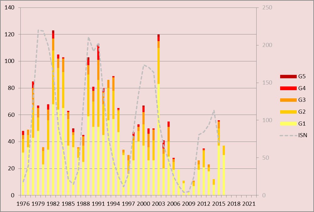
As you can see on the chart 24 solar cycle (11 years so basically starting at 2008 - 2019) 2012, 2015, 2018 were the strongest geomagnetic storms in the solar cycle 24. But even though these were the strongest geomagnetic storms in the solar cycle 24 there were no extremely , severe (kp=9) storms. But sadly these storms of the solar cycle 24 are the only strong or kp=8.
Now we can see these dates and when they were
July 2012 storm:
Do you know about the Solar Storm of July 2012? A solar storm happened during July but it involved large and strong coronal mass ejection. (on a SC24 its about KP=7) or KP=8 but not that strong to be KP=9) But the good thing is it missed earth by a margin of about 9 days. As the suns equator rotates around its axis over a period of about 25 days.
The region that sadly produced the outburst but it was not pointed directly towards the earth. Thus the stregth of the solar storm was been predicted to be comparable to the 1859 Carrington event. This solar storm was so strong that it caused damage to the electrical equipment worldwide. Which at the time consisted mostly of the telegraph system.
On the 23rd of July, 2:08 UT , a large coronal mass ejection (CME) launched from our sun. This eruption emanated from solar active region and coincidence with what was most an x2.5 class solar flare. Then the CME expelled a pair of adjacent magnetic clouds that emits fast mounting shock wave outward to our sun. As the eruption tore through the earths orbit it began hitting the stereo - a spacecraft, but this spacecraft is a solar observatory equipped to measure such activity abd thus it as far away from the earthand was not exposed to the strong electrical current that can be induced when a CME hits the earths magnetosphere. It survived the encounter and provided researchers with valuable data. Spacecraft obsevations recorded the shockwave at 20:55 UTC on 23rd Julywhile the magnetic clouds arrived two hours later. The elading shockwave associated with the CME was travelling radially at a speed of around 3,300km/s (2,200 M/s) relative to stereo A by the time it reached the spacecraft. The CME travelled from the sun to earth's orbit in about 20.78 hours indicating an average speed of 2000 km/s (1200 M/s).
2015 St. Patricks Day Storm.
2015 St. Patrick Days storm reached to a severe level on the NOAA Geomagnetic storm scale. The norweigan mapping authority operated a national kinematic positioning networkand in some recent years has developed software and service and deployed instrumentaion to monitor space weather disturbances. Thus, they recorded observations during the severe Geo magnetic storm. The strong GNS(Global Navigational Systems)disturbances were measured by the rate of the TEC index (ROTI) then observed all latitudes in Norway on March 17 and later on early March 18. after that, on late March 18 some strong disturbances were look at in northern part of Norway. as they study the Inospheric disturbances in relation to the Aurora electrojet currents. It showed that the most intense disturbances of GNS signals did occur on the poleward side of poleward moving current regions. This shows and indicates a possible connection to the Inospheric polar cap plasma patches or paticle precipitition caused by magnetic reconnection in the magnetosphere. They also studied the impact of the disturbances on the network RTK and precise Point Positioning(PPP) techniques.
August 2018 Geomagnetic Storm
CIR (Corotating Interaction Region) usually drivens magnetic storms are regular one for a solar cycle decreasing. In spite of that, CMES (Coronal Mass Ejection from the Sun) usually appeared during the solar cycle maximum. However CMES are rare to appear at the same time as the solar cycle declines. But since they are associated with flaresor filament eruptions. except these CMES are infrequent during the low part of the cycle. But then, the suns downward cycle 24, of powerfull magnetic storm. (March, June and December 2015, May and September 2017) all were happned by CMES. Strong magnetic storms on 25-26 August 2018 was the last storm of the 24 solar cycle. the CMES were connected with filament eruption on August 20 under the very low solar wind speed. A comparison of the two last sever magnetic storm (September 2017 and August 2018) ilustrate that there was no linear connection between the storm intensity ( DST Index) and also Planetary geo magnetic activity (AP Index). The planetary geo magnetic disturbances in September 2017 storm is more stronger than August 2018.
Now as we seen over these dates, the strong geomagnetic storm have affeted human travelling like take for an example the July 23 geomagnetic did hit the stereo-A spacecraft. as the CME( Coronal Mass Ejection) hit the satelite and the impact triggered a high energy particle background that created a snow like noise and its imaging instruments, the satellite survived, continue operating, and provided scientist with accurate data of the solar storm. But on 2015 St Patrick day storm, some observation talked about how some disturbances were made. These proves that geomagnetic storms can affect satellites, GMS signals and power grids.
Conclusion
Conclusion.
Aurora borealis does affect navigation systems. But when auroras are being made they are from solar wind, specifically coronal mass ejections, When these charged particles compress the magnetic field, then it triggers elect
Citations
https://ui.adsabs.harvard.edu/abs/2013SpWea..11..585B/abstract https://science.nasa.gov/science-research/planetary-science/23jul_superstorm/ https://svs.gsfc.nasa.gov/4177/ https://www.swpc.noaa.gov/sites/default/files/images/u33/StPatrick%27sDay_Geomagnetic_Storm.pdf https://britgeopeople.blogspot.com/2015/03/the-st-patricks-day-geomagnetic-storm.html https://www.spaceweatherlive.com/en/auroral-activity/top-50-geomagnetic-storms/year/2018.html https://www.sciencedirect.com/science/article/abs/pii/S0273117721006360 https://reeve.com/Documents/Articles%20Papers/Observations/Reeve_ObsMagStorm26Aug2018.pdf https://en.wikipedia.org/wiki/Geomagnetic_storm https://www.maine.gov/mema/maine-prepares/preparedness-library/geomagnetic-storms https://www.spaceweather.gc.ca/info-gen/index-en.php https://www.spaceweather.gc.ca/info-gen/index-en.php https://www.swpc.noaa.gov/content/aurora-tutorial https://scied.ucar.edu/learning-zone/sun-space-weather/aurora https://scied.ucar.edu/learning-zone/sun-space-weather/aurora https://www.space.com/aurora-colors-explained https://www.swpc.noaa.gov/content/aurora-tutorial https://www.earthdata.nasa.gov/data/space-geodesy-techniques/gnss https://novatel.com/an-introduction-to-gnss/gnss-constellations/beidou https://novatel.com/an-introduction-to-gnss/gnss-constellations/glonass https://www.ebsco.com/research-starters/engineering/glonass https://www.garmin.com/en-CA/aboutgps/ https://novatel.com/support/knowledge-and-learning/what-is-gps-gnss https://science.nasa.gov/mission/galileo/ https://www.esa.int/Applications/Satellite_navigation/Galileo/What_is_Galileo https://www.google.com/search?q=gnss+navigation+system&oq=GNSS&gs_lcrp=EgZjaHJvbWUqDAgBECMYJxiABBiKBTIRCAAQRRg5GEMYsQMYgAQYigUyDAgBECMYJxiABBiKBTIMCAIQABhDGIAEGIoFMgwIAxAAGEMYgAQYigUyDAgEEAAYQxiABBiKBTIMCAUQABhDGIAEGIoFMgwIBhAAGEMYgAQYigUyBwgHEAAYgAQyDAgIEAAYQxiABBiKBTIHCAkQABiABNIBCTg5MzBqMWoxNagCALACAA&sourceid=chrome&ie=UTF-8 https://www.unoosa.org/oosa/de/ourwork/psa/gnss/gnss.html https://www.swpc.noaa.gov/noaa-scales-explanation https://ui.adsabs.harvard.edu/abs/2024KPCB...40..105K/abstract https://thejemfoundation.com/how-solar-eruptions-can-impact-mental-health-exploring-the-connection/ https://www.forbes.com/sites/jamiecartereurope/2024/11/10/are-the-northern-lights-dangerous-experts-reveal-the-dark-side-of-auroras/
Acknowledgement
I would like to thank my mom for helping me where too put and organize the information ( I did all the information my mom just helped me where to place it.) I would also like to thank my dad for printing out papers with my information and for buying supples so I could glue my papers on the board.